How DRONES are used for SEARCH and RESCUE


How DRONES are used in SEARCH and RESCUE

Over the last several years, DRONES have emerged to become critical tools for Search and Rescue operations. There is no better way to validate drones’ usefulness to society than to save human lives. This article will show you how you can support Search and Rescue with your drone startup business.

One year later, this number doubled. And this number continues to increase as more public safety departments adopt drones into their daily operations.

Drones have proven so useful, that the U.S. Department of Homeland Security (DHS) Science and Technology (S&T) Directorate established a First Responder Robotic Operations Systems Test (FRROST)  program specifically to evaluate the utility of unmanned systems to the Emergency Response mission.  The results of this test program will likely be a significant government investment into incorporating drones into organizational operations.

Like any tool, drones do not provide a silver bullet to instantly eliminate all challenges with Search and Rescue (SAR) operations. But, if used correctly, drones can provide a valuable source of information that increases the chances of a successful rescue.

How Drones Help SAR (search and rescue)

In Search and Rescue (SAR) operations, minutes matter. Those minutes can come in the form of understanding the terrain, coordinating actions amongst the rescue team, determining the proper equipment for rescue teams, refining the subject location, or extending the subject’s life expectancy. 

The ability to put an imaging sensor in the air, well above any natural human perspective, is a tremendous advantage to teams that are otherwise using paper maps and eyeballs. Moreover, the overhead moving map imagery on most ground control station (GCS) software is probably a generation ahead of what most public safety agencies are equipped with. 

Before we dig into the specifics of equipment and piloting techniques, let’s take a step back to appreciate the conduct of a professional SAR operation. 

Search and Rescue (SAR): The search for and provision of aid to people who are in distress or imminent danger. 

SAR can be traced back to ancient times: a child is lost in the woods, a soldier is wounded on the battlefield, or a fishing boat is overdue for its port call. Ironically enough, our technology and techniques for locating and aiding these subjects has not substantially changed since the days of old: the primary sensor remains the human eyeball, and the primary method of location remains a paper map (perhaps an electronic copy of a paper map for some technophiles)

We will be using the term subjects throughout this article to reference the lost or distressed victim, as a matter of professional practice. This is analogous to the usage of terms such as patient and client in other professional fields. It is not intended to dehumanize those whose lives are in danger; rather, it is intended to let us take a clinical, unemotional approach conducive to rational analysis and critical thought.

Public Safety

The Public Safety sector includes Federal organizations (FEMA, DoD, DHS) and state/local organizations (law enforcement, emergency response). The scale of an incident will often dictate at which level the SAR operation is coordinated: small scale events may be addressed by a local Emergency Response Team (ERT) under the purview of a County Sheriff, while larger scale events may be worthy of a DHS-sponsored SAR Task Force. 

A professionally-led, government-sponsored SAR effort will normally designate a Search Commander (or SAR Commander). This individual is often a specially-trained veteran of SAR operations, bestowed with some level of tasking authority over supporting organizations. 

An Emergency Response Team (ERT) or Rescue Task Force should be comprised of individuals and organizations representing a variety of skills and equipment:

  • airborne surveillance
  • all-terrain mobility
  • breaching and extraction equipment
  • medical response

     are a few examples of who would participate in such an endeavor. The SAR Commander’s role is to synchronize the efforts of these diverse teams: airborne surveillance locates the subject and reconnoiters a route, the mobility team transports the rescue team there, the rescue team uses special equipment to reach the subject, and the medical practitioners provide resuscitative and rehabilitative treatment. 

Public Safety agencies can operate under either a Public Aircraft Operations (PAO) Certificate of Authorization (COA) or a civil Part 107 equivalent.  

PAO COAs are generally reserved for government owned and operated drones, and might be the airspace authority of choice for a law enforcement drone team.

As a private individual, you can absolutely volunteer your services to a local Emergency Response Team. At the time of this writing, you would likely have to support the efforts under Part 107 rules, and would not likely be entitled to compensation for your efforts.

Commercial Drone Search and Rescue Services

Commercial DRONE Search and Rescue Services

While missing persons may trigger a public safety response, there are still occasions for the drone entrepreneur to conduct SAR for hire.  

  • Lost pets
  • Lost belongings

People can, and do, lose pets and belongings every day, and many are willing to hire assistance in locating and retrieving their valuables. These may not be the most exciting, or news-worthy, but Law enforcement may not be willing to search a deep canyon for a dog, or a long stretch of roadway for a suitcase that fell off the truck, but a private drone pilot might.

And as a side-note, these operations can be the most rewarding from a good will perspective as well as bringing positive exposure to the drone community and your drone services business.

top drones for search and rescue
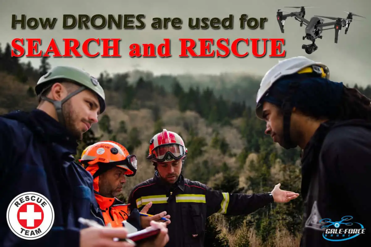
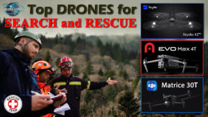
Click in to my article “Top Drones for Search and Rescue Operations” to see what drones are recommended for SAR.

Search and Rescue Equipment

We will start this section off by simply stating that if you have an airborne camera, there is probably some work you can do in a SAR operation. But not all airborne cameras are created equal, so let’s dive into the specific components of your drone setup to see how you can best support SAR operations.

  • Aircraft. You will want a reliable aircraft with sufficient lighting for the environmental conditions you are operating in.
  • Battery/Fuel. Not only does a good battery give you the most flight time, you will probably want several of them to give the most coverage on station. It can take several hours to locate a subject within a few square miles; this might require a dozen batteries to fly in a single day! For fuel-powered aircraft, you may be refueling several times to cover the entire search area.
  • Datalink. If you are fortunate enough to be able to maintain line of sight at short ranges over the entire search area, then most datalink types should be sufficient. In many cases, it is probable that the search area can extend for many miles, and you will want to ensure that your datalink can range these distances. It is also helpful to receive real-time imagery from your drone during the search.
  • Navigation. Without the ability to match an image with a latitude/longitude point, the image loses value. For best results, you should be able to derive the locations of both the drone and its sensor point of interest (SPOI).
  • Sensors. Daytime camera is good. Night vision is good. Thermal imaging is good. Still images are good. Full motion video is good. Radar is good. LIDAR is good. Essentially, it’s all good, but for different purposes. For example, creating a high-resolution mosaic map of the search area is probably best done with daytime still images, while searching for a moving subject at night may be better accomplished with thermal video. Identifying terrain obstacles through light foliage might be best suited for a radar or LIDAR sensor. These things matter, because once the subject is located, they still need a rescue team to get to their location without falling victim to the same dangers that led to an injured subject in the first place. There is not a good “all-purpose sensor” to cover every possible use case in a SAR operation.
  • Ground Control Station. Ideally, your GCS software can support both automated flight and manual flight. Many GCS solutions come with pre-built search patterns, only needing you to identify the search area.
  • Map and Imagery Displays. Part of coordinating with the rest of the SAR team is sharing information. If you are the only person that can see your moving map and imagery feed, expect a lot of people to be fighting to look over your shoulder. It can be highly useful to use a repeater screen to display your map and imagery to the rest of the team, several feet away from you.
  • Communication System. If you are using a Visual Observer to satisfy BVLOS requirements, you probably already have some experience with various communication devices. In addition to your own flight crewmembers, you will want a way to communicate with the Search Commander, any other participating aircraft, and eventually the rescue teams themselves. Few things are more frustrating than watching somebody walk right past the subject without realizing it, just because you could not communicate with them directly.
  • Speaker. Some Public Safety organizations have found utility for putting a loudspeaker on a drone. This can be useful for communicating with the subject and rescue team if other methods have not been established.
  • Spotlight. During night flights, a spotlight gives a good indicator to the subject of where you are searching, and can also illuminate the subject for rescue crews.
  • Cargo System. Depending on the subject’s condition, a cargo system can be used to deliver survival material to the subject until the rescue team arrives on scene.

Working with Local Authorities for Drone Search and RescueClick in to my article “Working with Local Authorities for Drone Search and Rescue” to learn how to PROPERLY ENGAGE with local government agencies, Emergency Rescue and First Responders.

Search and Rescue Organizational Preparation

The equipment itself represents only part of the equation; the remainder of the challenge lies in how its practitioners employ it. This is a combination of:

  • organizational readiness
  • piloting technique
  • and SAR team tactics, techniques, and procedures (TTPs)

SAR is almost never an event that is scheduled days in advance. Recall that minutes matter in many cases. To truly bring the technology to bear, the organization needs to be ready to execute on-call. Here are a few tips to get you into the fray, without delay.

  • Night waiver. If your equipment makes sense to fly at night, then having an approved night waiver doubles the time you are available to participate in SAR operations.
  • BVLOS waiver. Since SAR operations rarely occur adjacent to a convenient parking lot, it can be very useful to have authority to fly outside your immediate line of sight (typically about 1 km).
  • Alert posture. Be ready to go at a moment’s notice! Maybe not a moment, but think about what it would take to be ready to launch in one hour. How many batteries do you keep at/near full charge? How long does it take you to check weather and NOTAMS? Is your flight bag packed and ready to go? Did you do your pre-flight maintenance before you packed the drone away after your last flight? Does your SD card have enough space? Do you have a blanket airspace authorization for the area?
  • Drone insurance. Depending on your policy, you might have 24/7 coverage, or you might have on-demand coverage. Ensure you have a way to quickly activate on-demand coverage, so you are not waiting on insurance approval for hours or days.
  • Rapid contracting. If you are volunteering for a local ERT, make sure that your documentation with them stays current – do not wait for an emergency situation to determine that your paperwork has lapsed. If you choose to offer your services for hire, have a pre-priced template contract available, preferably with digital signatures. If you are contracting to an organization that routinely conducts SAR operations, you can even consider an ordering-agreement type of contract in which the client simply places a pre-priced order for your services on a pre-approved contract.

Even if your drone startup business is postured for immediate response, the rest of the SAR community may not be able to react so swiftly. Imagine, for an instant, that you were able to locate the subject 20 minutes after the initial call. If you have not yet established solid TTPs with the Search Commander, the rescue helicopter may be restricted from launching due to a drone in the area, hours after you have landed!

Poor preparedness and team coordination has been the downfall of many SAR operations. In the most optimistic scenarios, you will conduct unnecessary flight time while the rest of the Search Team catches up to the situational awareness you have built. In extreme cases, the best thing you can do is keep your drone on the ground until all coordination has occurred.

How hto

How to Operate Your Drone
SEARCH and RESCUE Practice

We have spent a lot of time discussing how to prepare for SAR operations, but how exactly do you do it? If you are serious about being a SAR pilot, then the best thing you can do is enroll in a professional course on the subject. These come in a variety of delivery formats, probably last multiple days, and most likely cost more money than you will make flying SAR as a commercial pilot. 

SAR operations often start with a sense of urgency, and many can last for days.

Amateurs hope for luck, while professionals execute a rigorous plan.

Here, we’ll give you a quick primer on the basic principles, in case you ever find yourself in an ad hoc SAR operation.

Probability of Detection in Visual Searches

Search

  1. Setting Up The Gameplan
    • Define the Subject. What, exactly, are you looking for? Is it an individual or a group? Is it a teenage male or a geriatric female? What are they wearing? What equipment do they have? What are they most likely to do if lost or injured? How long can they reasonably survive if not rescued?
    • Define the Search Area. If possible, identify the search boundaries with geographic coordinates on a map. Start with the subject’s last known (or suspected) location, and work from there. Can you estimate how far they may have walked since they were last seen? How far might the water current have brought them? Are there any natural or man-made boundaries that they would not cross?
    • Determine Most Probable Route/Location. Are there any paths that the subject might be following? Are there calm areas in the river that may have allowed the subject to reach the shore? Is there an open field that the subject may have found to be easier to spot from the air? Try to determine some “most-likely” zones, followed by some “least-likely” zones, and prioritize the search accordingly.
    • Map the Search Area. A SAR team will probably start with a map and years-old satellite imagery of the area. If your equipment allows it, start by updating the overhead imagery of the search area to get a better appreciation for how it looks today. Try to get a sense of foliage density, water depth, and road conditions.
    • Locate obstacles. A rescue team might encounter unforeseen obstacles, such as fallen trees and washed-out bridges. Help them identify these before they depart, to ensure they are equipped with the proper tools to overcome these obstacles.
  2. Locating The Subject
    • Change Detection. If you have a still imagery sensor and change detection software, you might be able to locate evidence of the subject by comparing some “before-and-after” images. Highly-sensitive change detection can recognize objects that have moved, footprints in the sand, or items dropped by the subject.
    • Moving Object Detection. Full-motion video and some radar sensors can detect moving objects such as a person walking. There will be a lot of natural motion in most scenes, but motion detection can narrow the search space in some environments.
    • Visual Images. You never know when you’ll get lucky enough to spot the subject in bright-colored clothing waving at the camera. It happens.
    • Thermal Images. Thermal imagers are particularly helpful at night, when humans, animals, and fires tend to give off a warmer signature than the area around them. Look for some telltale indicators.
  3. Search Patterns
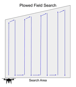
    • Plowed Field Search. To ensure complete coverage for initial mapping or searching a large area, the Plowed Field Search uses a series of parallel lines to thoroughly cover a large area. Be sure to build in some overlapping coverage between each successive pass.

Plowed Field Search

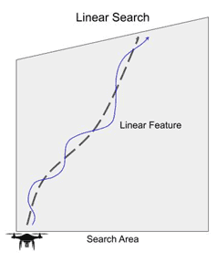
    • Linear Search. When searching along a linear feature (road, river), scan along the feature, including 25-50m each side within the field of view.

Linear Search

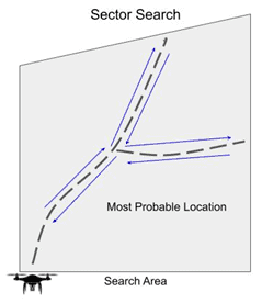
    • Sector Search. When multiple linear features or probable routes intersect, scan along each one individually to the point of farthest advance (the farthest the subject is likely to have traveled), and return to the starting point to scan along the next route.

Sector Search

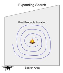
    • Expanding Search. When there is a likely area the subject is known or suspected to have been, scan outward in a spiral or box pattern, progressively increasing the distance from the centerpoint.

Expanding Search

  1. Share Information
    • Detections. If you observe something of interest (an obstacle, evidence of the subject’s presence, or the subject themselves), record all useful information and communicate it to the team.
    • Mark the map. Most GCS maps allow you to create a marker over an area of interest. This marker should include a timestamp (the date/time of when it was first observed) and detailed description.
      • “Large tree fallen across road”
      • “Hot campfire ashes”
      • “Human walking west, orange shirt, slight limp”
    • Take a snapshot. Try to get a screenshot of your moving map and image screen for every point of interest. Share this information with the rescue team, to build the collective situational awareness.
    • Gather information. Attempt to learn more about the subject’s location and condition. Will the rescue team need special equipment to move a large rock or log? Will they need ropes or ladders to reach the subject? Will the subject require a stretcher or immediate lifesaving equipment? It is best to learn this information early, before the rescue team departs with the wrong equipment.

Rescue

Once you have located the subject and passed on all information to the Search Commander and rescue teams, you can either call it a job well done, or you can stick around to support the actual rescue operation. Here are a few ways that drones can support the Rescue portion of a SAR operation.

  • Provide Hope to Subject. A subject that knows that help is coming has a higher chance of survival than one who has simply given up hope. Fly close enough for the subject to see and hear your drone, circle them a few times, or flash the lights–anything to indicate that they are seen, and that help is coming.
  • Lead Subject to Safety. Depending on the subject’s state of mind, they may wildly follow your drone as if it could carry them away to safety. You may be able to use this to your advantage by leading them toward a road, field, or other suitable site for the rescue team. If you are intentionally letting them follow, be sure to fly slow enough to continually beckon them forward. Ensure that this plan is approved by the Search Commander, as a mobile subject may be hard to relocate.
  • Terminal Guidance to Rescue Teams. You have a birds’ eye perspective of the world, but the rescue team does not. They may not be able to see the subject 10m away through the treeline. Simple verbal direction (“Subject is at your 10 o’clock, 25 meters”) can go a long way in the end-game of a rescue operation.
  • Marking Subject. If your drone is equipped with a spotlight, beacon, or other signal device, it can highlight the subject’s location for rescuers. Even hovering overhead or circling the subject can give valuable guidance to the team when the hills and trees all look the same.
  • Communicate with Subject. If your drone has a speaker, it can be used to give instructions to the subject. Even if it has only a cargo hook, this can be used to drop a note with a map or directions of how to move toward safety.
  • Drop Kits. If you can deliver cargo, then you can potentially extend the life expectancy of a hard-to-reach subject. Useful survival materials vary by environment, and you may have to make a few trips, but here is a list to start from.
    • Water
    • Food
    • Floatation devices
    • Blankets
    • Bandages
    • Flashlight
    • Flares
    • Matches
    • Map

In Conclusion

We’ll wrap up this article with a few nuggets from a professional public safety pilot.

  • Planning and developing a search strategy before executing the flight is essential.
  • There is no need to waste flight time if it has a low chance of being successful.
  • Success was less dependent on previous team familiarization and more likely when ad hoc flight team members had standardized training.
  • Drones are a great tool, but we public safety pilots can’t save lives alone. Teamwork and training matter.

If you take nothing else away from this article, please remember this: in search and rescue, you are part of a team. The success of the operation depends on how well the team performs, more so than any individual member.

As drone business professionals, we can all do our part by ensuring that we have the proper equipment, organizational readiness, and personal pilot training to be successful. But these elements alone will not guarantee a successful search and rescue operation. Rather, we must develop the professional relationships with our public safety agencies, and develop organizational TTPs to work seamlessly with the Search Commander and rescue crews on the ground. After all, we are here to save human lives, and that is the true measure of success.

How To Get Your FAA Part 107 Pilot Certification

If you are serious about making money with your drone, whether it be Real Estate, Aerial Inspections, etc., then you will need, from the FAA a 14 CFR Part 107 certification.

The best source for your training can be found by clicking on RemotePilot101. Jason Schappert is a pilot and author of 8 best-selling aviation flight training books. While studying and taking tests is not the most fun, Jason breaks it down into 10 easy to follow (at your own pace) video lessons. These lessons are straight and to the point giving you the exact knowledge, nothing less, nothing more than what you need to pass the exam. Additionally, he is continually updating the training to keep it relevant to any changes to FAA regulations. This membership is a 1-time subscription – for life! So when you’re 24 month renewal comes around, just sign in to RemotePilot101 and refresh your training.

Just remember, if you are flying commercially, you will need your Part 107 certification. It’s not hard, you can do it!

Recent Posts