How Drones Are Using AI To Fly Anywhere By Themselves


How Are Drones Currently Being Flown?

There are 4 primary ways that drones are currently flown:

  1. Computer provided guidance instructions
  2. Flight plans based on GPS and/or other beacons
  3. Flight plan based on an embedded or internal map
  4. Or flown manually by a qualified Pilot in Command

Can AI Be Used To Fly Drones By Themselves?

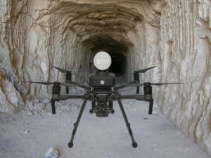
According to various technology companies, upon the installation of artificial intelligence to the drone, the drone can then fly itself without the need of built-in flight apps, internal maps, GPS, remote control or pilot operator. In fact, Exyn Technologies, in particular, claims to have the first drone that can fly anywhere, autonomously. 

The term “autonomous” is thrown around rather generously in conversations regarding drone operation. Drone services such as aerial mapping, LiDAR, aerial GPR, these can be performed by plotting a flight plan into the controller using various flight planner applications. The drone is launched and begins flying the plotted mission, autonomously. Just to be clear, this is NOT what we are discussing in this article. Those types of missions use GPS and other types of beacons for positioning. 

What we ARE discussing is the true definition of autonomous flight. As mentioned at the top of this writing, it is important to re-iterate that this technology does not require GPS or a pre-plotted, pilot flown mission. While there may be tasks that are pre-programmed, the drone literally flies the mission by capturing data in real time and navigating the mission on it’s own.

What Industries Needs AI Drone Services?

Think of it this way, industrial environments, whether man-made or natural environments that are hazardous to human workers, this technology is essential.  

In the mining industry, with humans working underground, the risk can be extreme, or out-and-out dangerous to human workers. A drone flying autonomously can capture important data while keeping workers out of harms way, and minimizing the costs that go hand in hand with injury or worst case scenario, death. By flying a drone into a newly blasted area of a mine, the drone can capture data that allows for analysis of the structure for cave-ins, or settling that can affect both the new blasted area and other areas of the working mine.

These mine shafts can be hundreds of feet, even miles below ground where there is no access to GPS or radio communications for remote controlled flight. Along with the safety assessment described above, the drone will also provide data for mapping of the new area by use of various types of scanning sensors.

Among these, LiDAR, or light detection and ranging, uses a pulsed laser to calculate an object’s variable distance from the Earth surface. These light pulses – put together with the information collected by the airborne system – generate accurate 3D information about the Earth surface and the target object. 

Other industries such as the Emergency Response sector will also benefit from the development of this technology. Imagine a burning building, rather than sending in a human to locate trapped or stranded victims, a drone flies in, capturing data in real-time to quickly assess the structural integrity of the building, even locating people needing rescue, and only then sending in rescue teams to extract these stranded people. Or perhaps a condemned building that is too risky to send in human workers. 3D modeling can be captured to assess any concerns prior to entry.

What Companies Are Offering This Technology?

In the beginning of this article, I mentioned Exyn Technologies, who has recently signed a deal with Sandvik Group to provide these autonomous drones for the mining industry. Other companies who are developing similar technology are Near Earth Autonomy, NTrobotics, Emesent and Flyability. 

In the coming months, Exyn has stated that they will be releasing more technology enabling multiple drones to communicate seamlessly with each other. We are already flying hundreds of drone swarms simultaneously for drone light shows. The hardware platforms are available, and with these companies innovating and developing these technologies, the sky is the limit. And yes, the pun is intended!

In Conclusion

Our only limitation is our imagination. Remember when the iPhone came out? Now it is an irreplaceable part of our daily lives. I remember when self-driving cars was only in the Jetson’s, yet here we are. 

Please feel free to let me know your thoughts on developing AI technology for drones. I would be most interested in applications and industries needing this technology! I am always interested in learning more! 

How To Get Your FAA Part 107 Pilot Certification

If you are serious about making money with your drone, whether it be Real Estate, Aerial Inspections, etc., then you will need, from the FAA a 14 CFR Part 107 certification.

The best source for your training can be found by clicking on RemotePilot101. Jason Schappert is a pilot and author of 8 best-selling aviation flight training books. While studying and taking tests is not the most fun, Jason breaks it down into 10 easy to follow (at your own pace) video lessons. These lessons are straight and to the point giving you the exact knowledge, nothing less, nothing more than what you need to pass the exam. Additionally, he is continually updating the training to keep it relevant to any changes to FAA regulations. This membership is a 1-time subscription – for life! So when you’re 24 month renewal comes around, just sign in to RemotePilot101 and refresh your training.

Just remember, if you are flying commercially, you will need your Part 107 certification. It’s not hard, you can do it!

Recent Posts