What is Drone Photogrammetry?


what is drone photogrammetry

Hello and welcome to my website! If you’re a drone startup, or you’re looking to take your business beyond the realm of basic consumer services, I am writing this article for you. Drone photogrammetry (or mapping and modeling) is an exciting technology that can open up a world of commercial opportunities for you. And by the way, is one of the top drone services that has exploded this year. By the time you finish reading, you should have a clear understanding of what drone photogrammetry is and how it can be applied in various industries.

Understanding Drone Photogrammetry

What is Drone Photogrammetry?

Drone photogrammetry is the process of capturing aerial photographs and stitching them together to create 2D and 3D models. It involves using a drone with a camera and automated software to gather data, which is then analyzed to extract valuable information for industries like real estate, construction, and engineering.

what is drone photogrammetry?

Easy to Learn and Perform

One of the great things about drone photogrammetry is that it’s not rocket science, and relatively easy to learn. In fact, my first client project was to fly a hospital campus and provide roof dimensions for the design of a solar installation. I conducted the flight mission with my DJI Phantom 4 Pro, using GS Pro as my flight app and DroneDeploy for processing. All with no formal training other than what I could find online.

Most commonly, for a drone photogrammetry mission, you will fly your drone over the designated area, capturing images every few feet to ensure thorough coverage of the target site. It’s important to note that clients often have specific requirements regarding elevation, overlap, and angle. If they haven’t provided these specifications upfront, don’t hesitate to ask for them. Clear communication with your clients ensures that you deliver the desired results and meet their expectations. By understanding their needs and tailoring your flight plan accordingly, you’ll be able to produce accurate and detailed photogrammetric models that impress your clients.

With the right equipment and software, you too can become proficient in creating high-quality models in no time. The advancements in technology have made it more accessible than ever before, empowering individual drone pilots to provide valuable services to various industries.

Wide Range of Applications

And the possibilities are vast! Whether you’re in real estate, construction, engineering, or even filmmaking and video game development, drone photogrammetry enables us to create topographic surveys, inspect infrastructure, monitor construction progress, generate 3D models for architectural visualization—the list goes on. The ability to capture precise and up-to-date aerial data opens up endless opportunities for individual drone pilots or startups.

showcasing your work

Applications of Drone Photogrammetry

Exploring the Potential in Diverse Industries

Let’s talk about the applications of drone photogrammetry. This technology has proven invaluable in numerous industries, but for this article, we’ll talk about the following; construction, engineering, and topographic surveys.

  • Construction – In the construction industry, for instance, drone photogrammetry provides a wealth of benefits. It allows for accurate site mapping, progress monitoring, and even virtual reality (VR) simulations for project stakeholders. By capturing high-resolution images and generating detailed 3D models, I’ve been able to help construction teams streamline their processes and improve efficiency. For example, I recently worked on a project where I used drone photogrammetry to measure stockpiles of construction materials. By comparing the before and after models, I provided precise volume calculations, saving the construction team significant time and effort compared to traditional manual methods. Drone photogrammetry opens up new possibilities for accurate and efficient measurement techniques in construction projects, revolutionizing the industry.
  • Engineering – Engineering firms also find immense value in drone photogrammetry. From site inspections and structural analysis to creating digital terrain models, this technology enables engineers to make informed decisions with precision and accuracy. By utilizing drone data, I’ve been able to provide assistance to them in designing infrastructure projects and identifying potential issues before they become costly problems.
  • GIS Surveyors – benefit greatly from drone photogrammetry. With the ability to capture vast areas in a short time, we provide a faster and more cost-effective alternative to traditional surveying methods. The accurate and detailed models generated through photogrammetry allow for comprehensive analysis of terrain, enabling urban planning, land development, and environmental assessments.

Through my experience, I’ve witnessed firsthand how drone photogrammetry revolutionizes processes for these industries. By leveraging the power of aerial imagery and data processing, businesses can achieve greater efficiency, accuracy, and productivity. Embracing drone photogrammetry opens up a world of possibilities and a competitive edge in the marketplace.

Start Making Money with your DJI Air 2SClick in to my article “Can I Make Money with my DJI Air 2S?” to learn about this affordable drone and it’s amazing capabilities!

DJI Mavic Mini

What Drone Do I Need for Drone Photogrammetry?

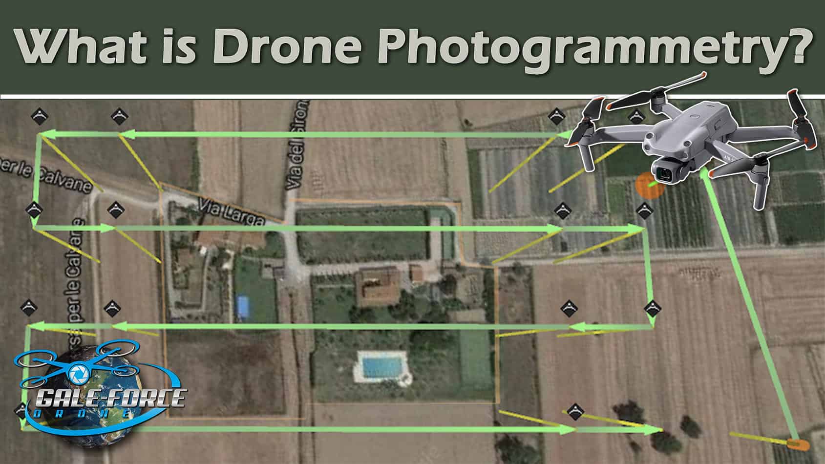
For drone photogrammetry, choosing the right drone is an important component to achieving accurate and high-quality results. In the following, I will go through the three main categories of drones: Entry-Level, Mid-Tier, and Top Tier, each with its own set of features and capabilities.

An important note however, is to remember that I started performing legitimate photogrammetry services with my Phantom 4 Pro, so keep that in mind and don’t feel like you have to go out and buy the most expensive drone.

Entry-Level Drones

Entry-level drones like the DJI Mini 3 Pro and the Autel Robotics EVO Nano Plus are great options for drone photogrammetry. These drones are not only affordable but can also be maximized for large-scale projects with the right techniques. While they may have some limitations in terms DJI Mavic Air 2S
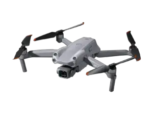
of camera resolution and flight time, they can still deliver impressive results when used effectively.

Advanced Drones

My recommendation to individuals looking to get into drone photogrammetry, would be to consider what I consider to be Mid-Tier or advanced drones that offer enhanced features and capabilities. Models like the DJI Mavic Air 2S, the Autel Robotics EVO II Pro, and the Skydio 2+ are equipped with higher resolution cameras, longer flight times, and the ability to fly with third-party applications. If skydio 2+
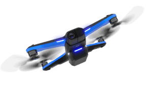
these drones are outside your budget, consider exploring the second-hand market where you may find options like the DJI Phantom 4 Pro or the DJI Mavic 2 Pro.

Enterprise Drones

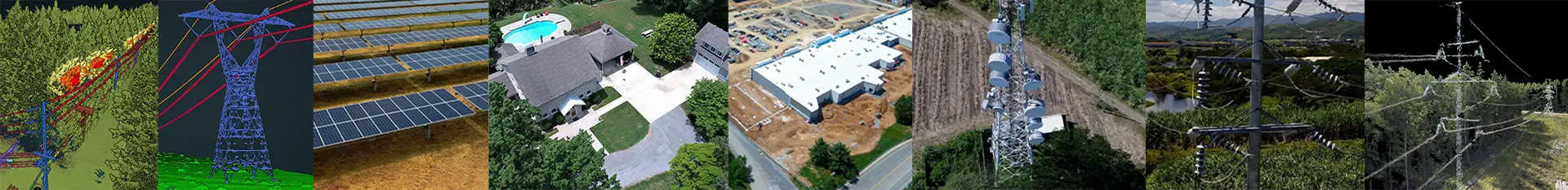
Enterprise-level drones aredji matrice 300 rtk 
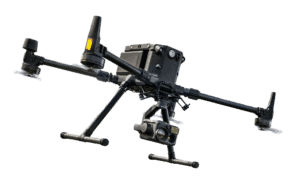
designed to meet the demanding requirements of professional applications. Examples include the DJI Mavic 3 Enterprise, DJI M30T, M300 RTK, and the Autel Robotics EVO Max Series. These drones offer advanced features such as thermal imaging, increased payload capacity, and precise RTK (Real-Time Kinematics) positioning, making them ideal for specialized industries and complex projects.

And of course, choosing the right drone depends on factors like your budget, specific project requirements, and long-term goals. So it’s important to consider the capabilities of each drone category and select the one that aligns with your needs to ensure optimal performance in drone photogrammetry.

By investing in the right drone for your desired level of expertise and project scale, you’ll be equipped to  capture accurate data and produce high-quality models, taking full advantage of what drone photogrammetry has to offer.

What Software Do I Need for Drone Photogrammetry?

To successfully conduct drone photogrammetry, you’ll need a combination of controller apps and processing software. And choosing the right software is essential to generating accurate maps and model deliverables from the data captured during your flights. In this section, we will explore various categories of software, considering both free options and paid solutions,enabling you to make an informed decision and optimize your drone photogrammetry workflow.

Acquisition Software (Controller Apps)

Acquisition software plays an essential role in planning and executing your drone flights. Here are some options to consider:

Free Options:

  • GS SPro (Ground Station Pro): A powerful app for DJI drones that allows for advanced mission planning, including automated flights.
  • DJI Pilot 2: Ideal for starting out, DJI Pilot 2 provides a user-friendly interface and basic flight planning features. It allows you to capture images and control your DJI drone seamlessly.
  • Map Pilot Pro: Another great option for beginners, Map Pilot Pro offers easy-to-use flight planning tools and efficient image capture capabilities. It is compatible with various DJI drone models.

Paid Options:

  • DroneDeploy: This popular cloud-based platform offers comprehensive flight planning tools and intuitive mission control for capturing aerial images with precision. It provides automated flight paths and real-time mapping capabilities.
  • Pix4Dcapture: With Pix4Dcapture, you can plan and execute automated drone flights, capturing images at predefined intervals to ensure proper coverage of your target area. The software supports various flight modes and can be tailored to your specific project requirements.
  • Dronelink: For more advanced capabilities, Dronelink unlocks additional automated flight plans and features. It enables 3D capture and provides dynamic automated video flight paths, expanding the possibilities of your drone missions.
  • UGCS (Universal Ground Control Software): UGCS  is a powerful platform that supports various drones and offers advanced mission planning capabilities. It allows for vertical capture and provides more flexibility in flight planning.

Processing Software

Processing software helps convert the captured images into accurate 3D models and maps. Here are a few reliable options:

Free Options:

  • Maps Made Easy: Maps Made Easy is a free option for processing drone imagery. It provides tools to create orthophotos, 3D models, and point clouds. While it may have limitations compared to paid software, it can be a good starting point for beginners.
  • OpenDroneMap: OpenDroneMap is a community-driven project that provides a suite of tools for processing drone imagery. It utilizes open-source libraries and algorithms to generate orthophotos, 3D models, and point clouds.
  • MicMac: MicMac is an open-source photogrammetry software that offers a range of features for processing drone imagery. It supports various camera models and provides tools for dense point cloud generation and 3D reconstruction.

Paid Options:

  • Pix4Dmapper: Pix4Dmapper is a powerful photogrammetry software that allows you to process the collected images and generate high-quality 2D maps, 3D models, and point clouds. It offers advanced processing algorithms and a user-friendly interface.
  • Agisoft Metashape: Agisoft Metashape is another popular choice for processing drone imagery. It enables you to create georeferenced orthomosaics, digital surface models, and dense point clouds. The software supports multi-sensor data integration and offers professional-grade accuracy.
  • DroneDeploy: Considered the industry standard, DroneDeploy offers a comprehensive suite of processing tools. It allows you to generate accurate maps, models, and insights from your drone data, empowering you to make informed decisions.
  • DJI Terra: DJI Terra, developed by DJI, provides advanced mapping and modeling capabilities. It supports automated flight planning and offers a range of analysis tools to extract valuable information from your drone imagery.
  • RealityCapture: RealityCapture is a robust photogrammetry software known for its speed and efficiency. It can handle large datasets and offers high-quality reconstruction and visualization options.

Remember, the choice of software depends on your specific needs, budget, and level of expertise. Most of these will offer free trials, so explore these options, try out their features, and find the software that best suits your drone photogrammetry workflow. With the right tools at hand, you can unlock the full potential of drone photogrammetry and take your projects to new heights.

Ensuring Accuracy in Drone Photogrammetry

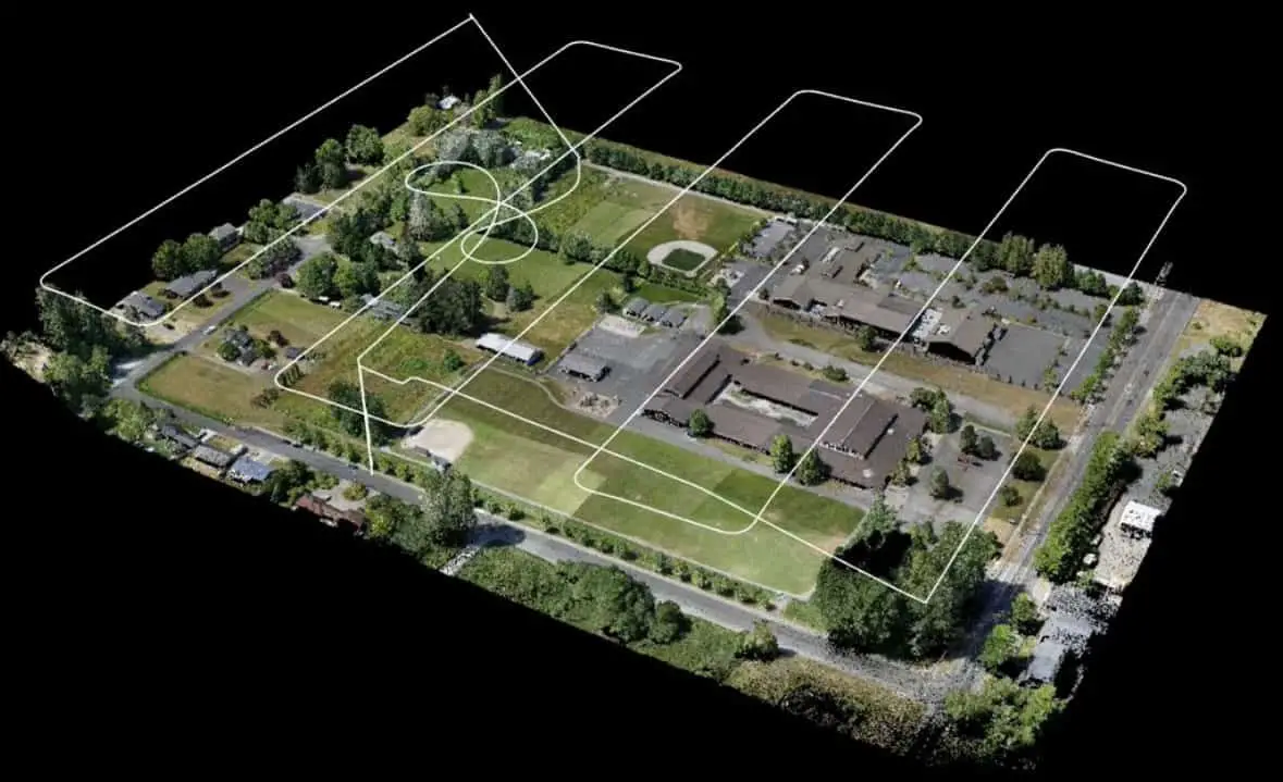
Accurate data is paramount in drone photogrammetry as it directly influences the quality of the final models. To ensure precise results, I employ various methods and techniques throughout my workflow.

Importance of Accurate Data
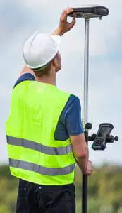
 GIS Engineer GCP RTKCapture

Maintaining accuracy in drone photogrammetry is required in order to deliver reliable and trustworthy outputs. Whether it’s creating 3D models, conducting topographic surveys, or measuring stockpile volumes, precision is key. Our clients rely on the accuracy of these models to make informed decisions and drive their projects forward.

Utilizing Ground Control Points (GCPs)

One effective method for achieving accuracy is by using Ground Control Points. Personally I prefer this method based on the value and affordability of the solution. GCPs are physical markers placed strategically on the ground with known, precisely measured coordinates. By capturing GCPs in the drone’s images and referencing them during processing, I can georeference the model, aligning it with real-world coordinates. This significantly enhances the accuracy of the final output.

Harnessing Real-Time Kinematic (RTK) Technology

Another advanced (and more expensive) technique is Real-Time Kinematic (RTK) technology. RTK-enabled drones and ground stations utilize high-precision GPS signals to enhance positional accuracy in real-time. This technology provides centimeter-level accuracy, which, again, is required for accurate surveying and mapping deliverables.

By incorporating GCPs and/or leveraging RTK technology, I can ensure that my drone photogrammetry outputs meet the highest standards of accuracy. This allows me to deliver reliable data that clients can confidently use in their decision-making processes.

galeforcedrone how to start your drone mapping businessClick into my article “How to Start Your Drone Mapping Business” for a basic guide to building your own Drone Photogrammetry Business.

Getting Clients as a Drone Startup Ask Questions

Growth Opportunities and Future Trends

As a new Drone Startup Business, you will want to keep your eyes open for new growth opportunities and emerging trends in the industry. By staying ahead of the curve, you can position your startup for long-term success and continued growth.

Diversifying Services and Expanding into New Industries

I have found success, beyond the more common service offerings, by diversifying my services and catering to different industries. For instance, I expanded into sectors like  offering building and rooftop inspections to property management companies, construction monitoring, as well as solar far inspection and powerline inspection. By leveraging the power of drone photogrammetry, I have been able to provide valuable insights and solutions to clients in these industries, opening up new avenues for business growth.

Embracing Emerging Technologies and Advancements

To stay ahead of the curve, it’s also a good idea to constantly watch for trends and advancements in drone photogrammetry. The industry is continually evolving, presenting exciting opportunities for those who embrace emerging technologies. From AI-powered analytics and automation to improved sensors and enhanced flight planning software, these advancements are shaping the future of drone photogrammetry.

conclusion

Wrapping Up...

In conclusion, we’ve walked through the ins and outs of drone photogrammetry and the real potential for drone startups. We’ve discussed the process, applications, equipment, software, and the importance of accuracy. Now, armed with this knowledge of what drone photogrammetry entails, it’s time for you to seize the opportunities it presents. Embrace the technology, hone your skills, and offer drone photogrammetry as a valuable service. With dedication and strategic planning, you can tap into the growth, profitability, and success that awaits in the dynamic world of drone photogrammetry.

Recent Posts